|
Sub-24 Hour Overnight. A term that arose from the initiative to gently introduce new cyclists to touring by bike. The idea is that jumping on a bike and riding across the country might be a bit over-the-top for beginning tourists, but perhaps a short, easy-to-recover-from overnight camp trip might be the place to start to get your feet wet (sometimes literally). It’s a chance to test-drive your bike, your gear, your preparation, and maybe … yourself. How convenient that the Genesee Valley Greenway offers a neat little option to do that! As the Greenway heads south out of Mount Morris paralleling NYRoute 36, it takes a turn through the now-closed Livingston Correctional Facility and into the Sonyea State Forest. The original canal route and the subsequent railroad went into the Keshequa Creek Gorge, but severe erosion has left the original route impassable, so the Greenway trail winds up an old road into the forest and comes to a trail that accesses the gorge. DOWN into the gorge, one can find a nice single track trail leading to campsites along the creek. That’s our destination for a “First Run” of a Scottsville to Sonyea bikepacking overnighter. Our tiny “advanced scouting team” of myself and Karen of course, plus veteran off-road tourist Todd, and “bike packing newbie” Mark all planned to meet at the church/park parking lot in Scottsville at 10:00am. Even with the chance of rain, Karen was OK to ride down the Greenway from home in the city to Scottsville, a 17 mile warmup. Todd did the same from his home, 8 miles away, so Mark’s was the only car left overnight in the park … with permission, of course. We hit the trail. 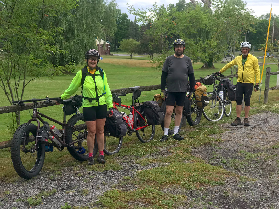 Ready ... 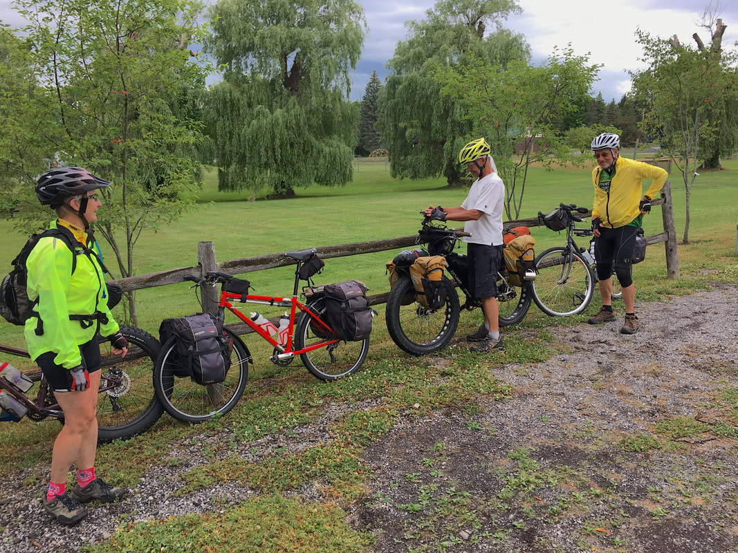 Set ... - photo by Todd Calvin 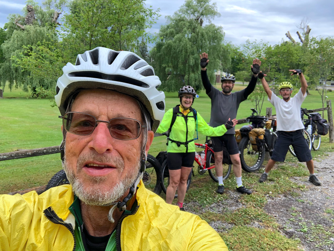 Go! - photo by Mark Robbins Heading out of Scottsville from Canawagus Park, our first stretch of trail has us riding the newly resurfaced section of trail between Scottsville and Route 5 just east of Avon. A major project, NYS Parks went all in on widening, clearing, installing a new base and top surface (stone dust … like on the Erie Canal in places) and adding amenities and water management structures. Wonderful work, but as I mentioned in an earlier post, the section south of Wadsworth Junction …  Wadsworth Junction 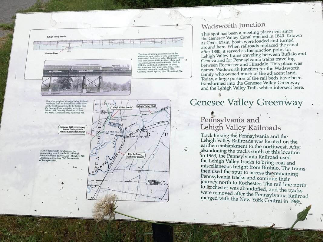 At Wadsworth Junction - photo by Todd … where the Lehigh Valley Trail crosses the river and connects to the Greenway … had seen heavy horse impacts on the trail. It seemed a bit less jarring this time, but perhaps because I was on my fat bike this time. Time will tell if the trail “settles” and packs down hard like others have. Just before reaching Route 5, we explored the Erie-Attica Trail that extends eastward from the Greenway toward the village of Avon and found that it too appears to have gained some attention, but it too has been pocked by horses. Not a problem for the right bike. The trail crosses the Genesee River …  Erie - Attica Trail. - photo by Todd … and stops at a parking area accessible from Route 5&20. From here, it’s easy access to downtown Avon for food and refreshments. Returning to the Greenway and crossing Routes 5&20, the trail reverts to natural surface, double track … 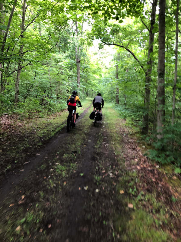 Back to Natural Surface. - photo by Mark … and leads us to the remains of the Genesee Valley Canal’s Lock Five. 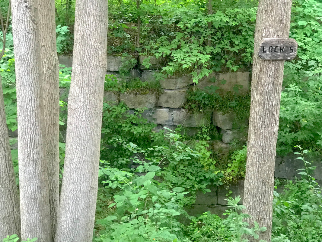 Canal Lock 5, just south of Route 20 It’s easy to miss with all the tree and brush growing up around it. Perhaps a work party can address this sometime? We continued south through Piffard and found our hopes for a cool drink dashed when we discovered that the Yard of Ale opens for dinner only, no afternoon bliss in air conditioning for us! 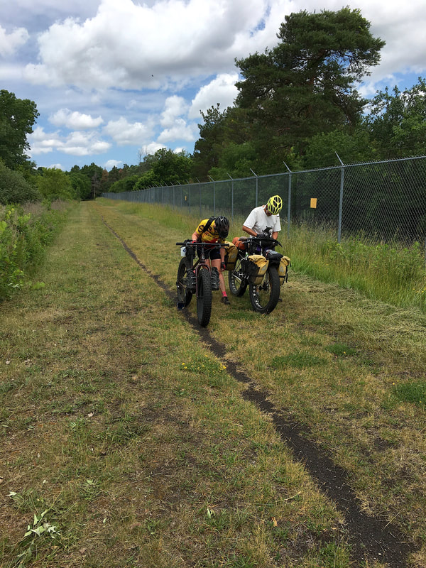 Technical Difficulties - photo by Todd Onward, we tried again for a break … food AND fluids …, but no luck in Cuylerville either as the Greenway Pub was open for drinks but wasn’t serving food. 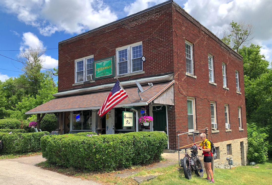 The Greenway Pub in "Downtown Cuylerville" - photo by Todd No problem … Mount Morris is just a stone’s throw. We planned on stopping here for supplies anyway, but the bartender at the pub suggested Brian’s (not MINE) USA Diner on the highway just north of the entrance to Letchworth State Park. We’ve been there and knew the food was good, so that became the dinner plan. After dinner, we hit the Kwik-Fill in town to stock up supplies, and headed south, but not before the obligatory photo on the bridge over the river in Mount Morris! 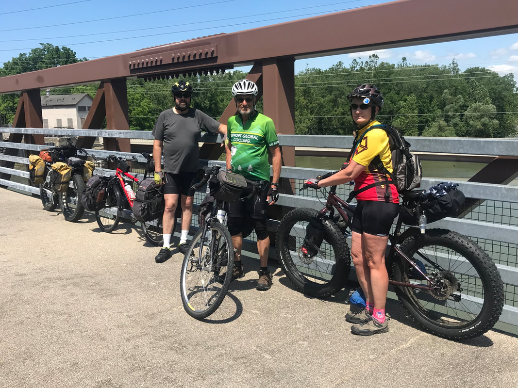 Greenway bridge over the Genesee in Mount Morris Mark, I’ll mention here, is just beginning to ramp up into this whole bike-touring thing and didn’t have all the gear, or capacity FOR the gear, so his plan was to ride with us to the gorge, but not camp there. Rather, Mark got a reservation at the Greenway Motel just south of Mount Morris and right across the highway from the trail. We could intercept him in the morning on the way to breakfast. Simple! So we pulled in there, Mark got checked in and dumped some gear, and we took off for the forest. It was a short stretch from the motel to turn into the grounds of the former Livingston Correctional Facility. Strange and spooky place! The grounds appear well kept, but most of the buildings look like something out of a Hitchcock film. Mark captured some interesting light on this one:  Was it a church, or ... ? - photo by Mark Anyway, we enter the forest via the closed off end of Union Corners Road. You can’t drive a car into the forest from this end, but you can get in via Tuscarora. The route in is little more than a double track till it gets to the gate restricting access to the gorge itself. Down we go into the gorge, riding it mostly, but dismounting to hike-a-bike down for the final drop to creek level. 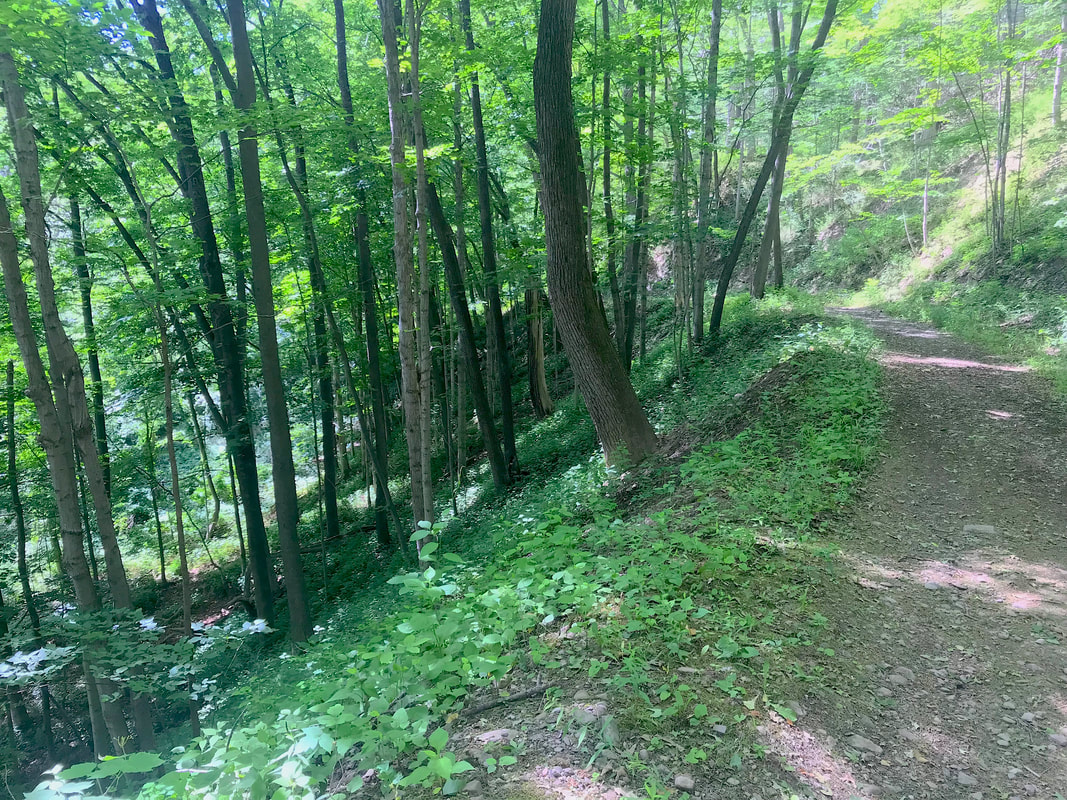 Down, down, down to Keshequa Creek And the reward? Perhaps one of the sweetest, discreetest little out-of-the-way campsites you could ever find. Alongside the creek with it’s waterfalls, pools and pollywogs, we find level tent sites, an impressive fire ring, and a selection of nicely spaced trees to experiment with hammock camping. 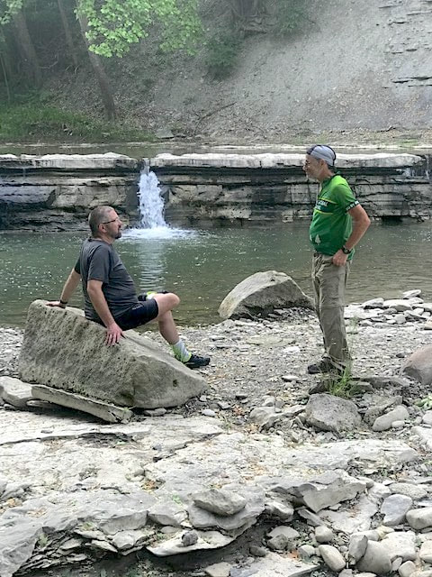 Waterfalls. - photo by Karen 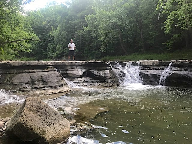 Waterfalls - photo by Karen  Waterfalls. - photo by Mark 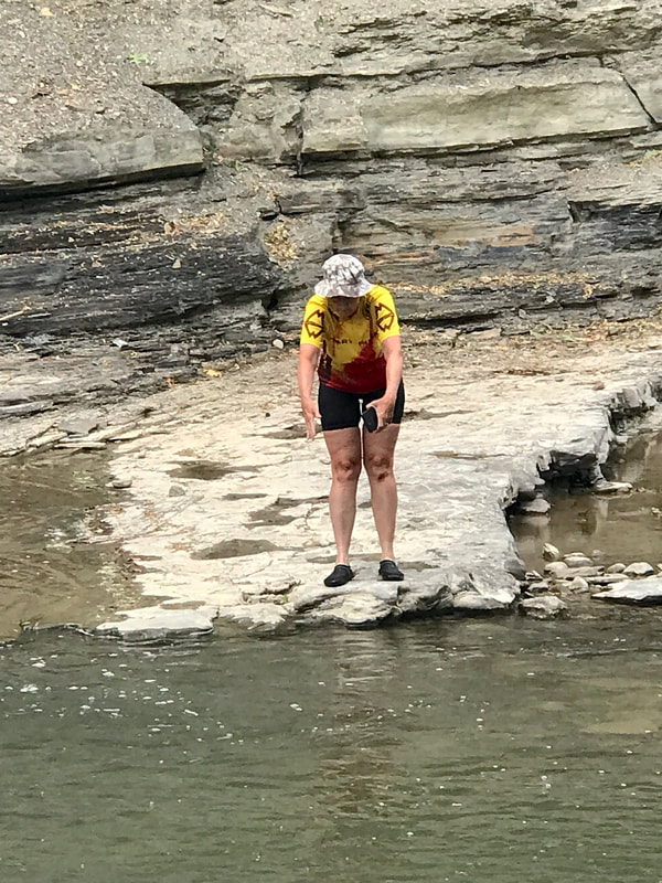 Look Look Look!! Pollywogs! 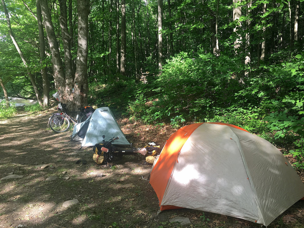 Excellent Tent Sites. - photo by Todd 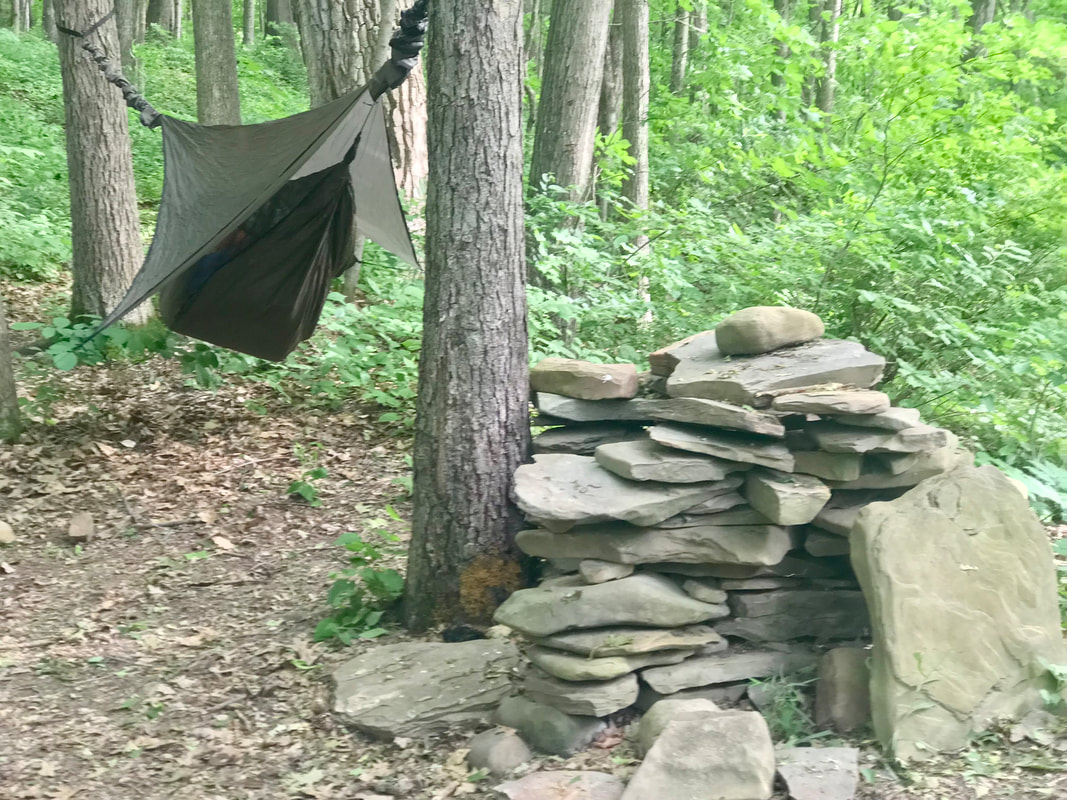 Hammock Camping 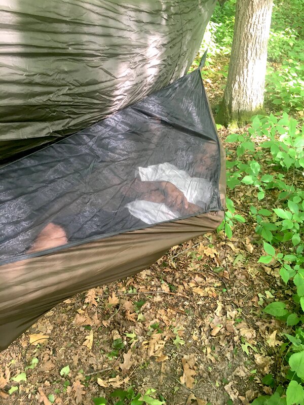 And I never fell out even once! - photo by Todd We “lounged about” with a really nice campfire while waiting for dark … when you’re ready to turn in while you can still see. 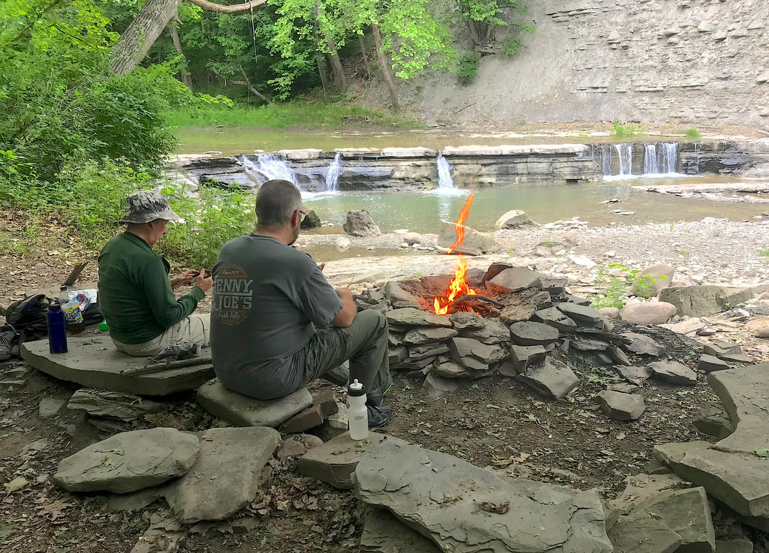 Hi-Quality Down-Time In the morning, we climbed out of the gorge and headed toward Mount Morris, bypassing the Greenway Motel and heading for the Radisson Country Inn where we meet Mark. Mark shared a harrowing story of a night-gone-bad at the hands of a less than hospitable desk attendant at the Greenway Motel. He "upgraded" to a bed at the Rad in town, and was surprisingly upbeat about the whole thing, Mark being Mark and all. I suspect he may be enthusiastically searching for gear for camping now. We all returned to Brian’s USA Diner for breakfast to fuel up for our return to Scottsville. Food was great and portions were “truck-stop standard”. Wow! A great day 2! Weather was warm and sunny and people were out enjoying the trail. We arrived back in Scottsville early afternoon but chilled for another hour or so at Artisan’s cafe. From there, Mark drove home, Todd had 8 more miles to home, we had 17. Wrapping up the overnight, Karen and I logged just over 100 miles on loaded fat bikes and slept really well that night. This overnighter proved out OK. We’ll plan another run to Sonyea!  Who's Ready for Beechwood State Park?
0 Comments
A reasonably cooperative weekend, weather wise, let me score some club ride miles in the style I like best … scenic! (AKA … Hilly!) It started with Saturday’s RBC #223, Naples-Haskinville ride; an “Al Davis” creation, on Mayday (May 1st). Long term members of the Rochester Bicycling Club get the Al Davis reference. The route is a 54 mile cruise in the hills south of Naples NY and the highlight of the ride MOST folks think of is Neil’s Creek Road, which meanders generally downhill and twisting along a creek valley for miles on a very, very quiet road. Sweet! It starts at around 25 miles into the ride and one pops out on the highway pointed to a food stop in Avoca at around mile 31 … IF you take the route unedited as people sometimes do. Why “sometimes”? Mack School Road is a barrier. It’s a nice road. And, unlike when this route was created, it’s nicely paved now (OK … chipsealed) and no longer a muddy dirt road. (Sniff!) But it’s got a bit of rather stiff climbing that can be avoided with a minor detour. The “moderate” group I was riding with that day elected to avoid it, but I blindly stuck to the main route, well, because. And because I was riding my Co-Motion Pangea, currently shod with knobby tires (on a road ride? Idiot!), I took a short-cut on the (dirt) Demmery Road which passes by a very old cemetery … 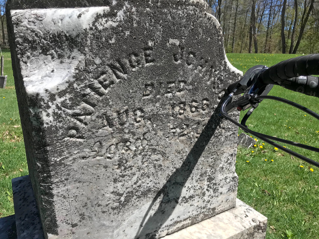 … before connecting with Mack School Road. OK … I’m a cheater. The reason I don’t have a reluctance to hit steep roads is GEARS. The super-low ratios of the Pinion gearbox on my Pangea allows me to climb grades that, quite honestly, SHOULD be avoided by any reasonable person on a reasonable bike. Never have been accused of being reasonable, I felt fully empowered to be myself and have a grand time. I barely intercepted my group later at the store in Avoca who arrived there much earlier and were just heading out. I skipped the chance for a slice of pizza, and rejoined the group , heading toward another classic section of the route, 12 Mile Creek Road. Our club has a few routes that use this road on the return to Naples, but I never tire of it. Ten miles of very quiet and nearly imperceptible climbing though the woods to the top of the hill south of Naples is a joy, particularly when it’s a sunny day with gentle southerly winds. But then … it’s a fast wild downhill on the highway to town to wrap up the ride. No complaints! 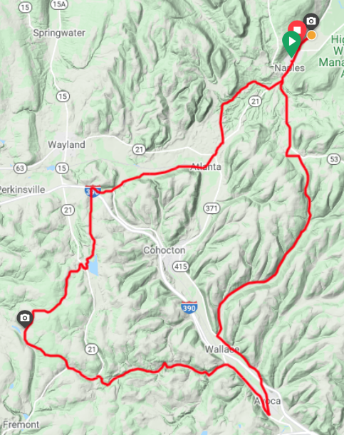 OK … THAT was cool. What’s next? Sunday, May 2. I’m the Ride Leader for yet another classic “Al Davis” ride: RBC #199: The Killer Hills. This time, the weather is looking “iffy”. Possible showers off-and-on most of the day, and not exactly warm enough to manage that without raingear. Wisely, most people I would normally expect to do this ride are no-shows on the club’s Meetup page. But Mike K. hangs in there till the last moment and decides shortly before the start to give it a shot after I make a post … “Do ya Feel Lucky?” We start from Geneseo with a few drops of rain that disappear quickly. After the first of 4 climbs, we’re cruising nicely till we get to the first of the two “memorable” climbs: Vista Hill. 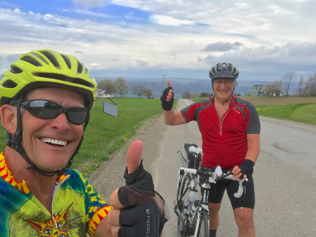 It takes a while, but we clear it OK w/o broken chains or broken bodies. Plunging down to Dansville via Sahrles Hill Road, we stop for coffee before the climb up Coffee Hill Road (see what I did there?), the second of the two “memorables”. Is there a better plan? This hill is a pretty tough grind as well, and we start hearing pinging sounds from Mike’s rear wheel spokes that suggest that he’s been torquing the crap out of it. We stop to check and it seems survivable, so we continue on. We enjoy a wild cruise down Kyserville-Byersville Road to highway 36 and we stop to evaluate the weather. We see rain ahead up on Groveland Hill. Radar on the smartphone says we are gonna get wet no matter which way we go. May as well stick to the plan! We cross the valley to Groveland Station, getting a bit damp from the “Heavy Sprinkles” (not quite a “light rain” in my weather spectrum), but as we turn up the hill, Mike mentions a wise proverb about the birds we hear singing … that they do that when the rain is about to STOP. 10 seconds later, the rain stops and the sun begins to cast our shadows on the pavement. Thank you Oh Wise Ones! Over the top and with a bit of headwind, we enjoyed the quick and general downhill back to Geneseo to wrap up a Really Cool Ride™, dry and happy that we “Felt Lucky” 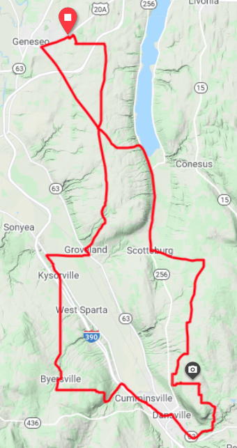 Nice Weekend!!!
It was a Beautiful Day for a Bike Ride today. OK, a little windy, but warmer, sunshine ... and ... oh yeah ... I'm retired too. Can it get better? I headed downtown into the west wind (15mph) to get to Java's where I could grab a pound of espresso ground coffee. (I ran outta coffee yesterday morning, so this was an "emergency" errand). After picking up the stash, I headed toward the River Trail and passed by the NOW OPEN skate park under the Freddie-Sue Bridge. Lotsa skaters. Awesome! Down the River Trail to Genesee Valley Park ... 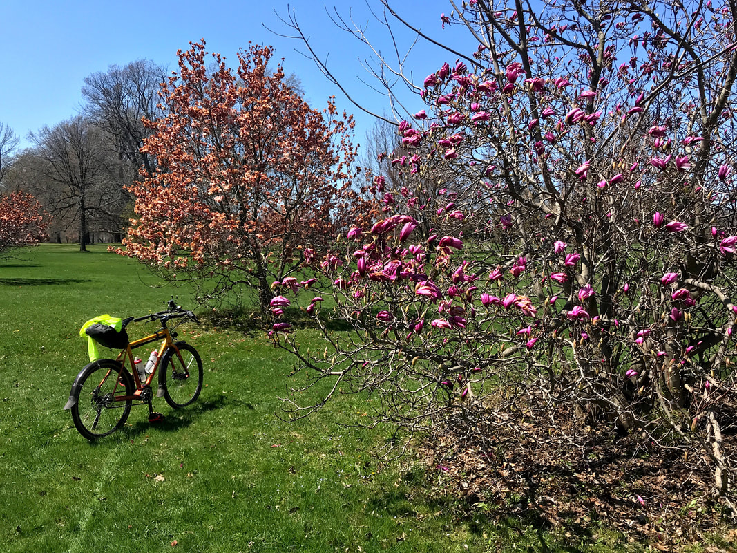 ... I cruise through, down East River Road and back into the trail before popping out onto Crittenden and just get started up the Lehigh trail back toward the Erie Canal and get a phone message. It was the vet's office. I call them back and tell them I'm in the area on my bike, and I'll be right over. I get there, wait outside the office, and a staff member comes out to hand me a bag. She says she's very sorry, and I can't even speak. I sit down on a bench outside for a while to gather myself before putting the package in my pack and head home sooner than I expected for today. I get to Cobbs Hill Park and see a pretty bed of flowers and think "what a nice picture that would make", so I stop.  I get home and look over the contents of the bag. 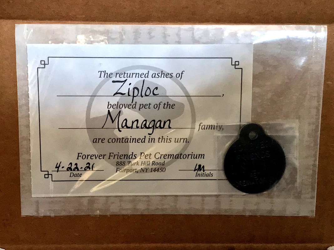 Even with the beautiful sunshine, this was a very dark day.  G-Bye Sweetheart. I Love You.
"… 'Cause two out of three ain't bad" The words went through my head on yesterday's century ride. I had plotted a route to Sodus Point / Sodus Bay area and as I often do, I allow Ride With GPS to make assumptions and serendipitously suggest the way. RWGPS is pretty smart for a brainless web-app, and doesn't often steer me wrong. But it's database isn't 100% up-to-date, so when things change … like roads getting closed … it doesn't always find out. But I do! After leaving Sodus Point southbound on Route 14, there's a side street called South Shore Road that I've always wanted to explore but never seem to have made the detour. Alas … RWGPS sent me that way and I dutifully followed my instructions. I immediately sensed that this might not work when I saw the string of fancy vacation homes along the shore with a view of the bay on a narrow street. This does NOT get thru-traffic, certainly. And the "No Outlet" sign confirmed it. But, on a bike "No Outlet" and "Road Closed" signs can often be interpreted in other ways like "Difficulty Ahead", "Hike-a-Bike Required", or maybe "Look Around, Be Quite, Ride Fast". Sure enough, I came to a spot where the road ended at a driveway, but I could see where the road continued on the other side of a manicured lawn between a couple obscenely expensive properties. It's a weekday, nobody around, and it takes only 15 seconds to cross one-man's land. As I pass the golf course nearby, I calculate the odds that the homeowners are club members as well.  South Lake Road @ Sodus Bay Shortly after, back out on Route 14, I take a favorite side trip down Red Mill Road and come to Ann Lee Drive. I've looked at that road on a map from the opposite end where it's named Spiegel Drive and remember that there IS a "Dead End" sign there … but not on THIS end. (Yet) Wouldn't you think I'd piece it together that they are two different roads, and thereby two different names. I didn't, so down Ann Lee Drive I go. Eventually, I DO run by a "Dead End" sign, but I'm already headed downhill with a tailwind and I'm not about to stop. Might as well be prepared to eat it and have to climb back uphill into the wind just for the sake of future knowledge why NOT to go this way. Again, the road (with no thru-traffic happening) ends at a driveway, but with a rusted old gated barrier looking what appears to be an old, now abandoned and grown over driveway. My satellite view shows Spiegel Drive on the other side, but it's not in sight through the woods. I compare the effort of hike-a-biking for a unknown result thru the woods to the long uphill headwind backtrack. Not entirely fond of "hike-a-bike" in the mud, but I hate "backtrack" as a word. I go. Sticks get caught in my drive-belt, mud cakes up on my shoes and tires and clogs in my fenders and my thoughts revert to Baja California until I see light through the trees. Sure enough, I see pavement connecting to a dirt driveway that leads me past a couple cabin-like homes. I quietly remount at the dirt and spin quickly outta there, out Spiegel and out to Ridge Road.  Ann Lee = Speigel Road ... Sorta So far, I've done everything RWGPS told me to do! South and westbound from there I eventually get to Fish Farm Road. I wonder why it's called Fish Farm when ALL the farms around me are apple orchards. Whatever. Then an AHA moment! I recognize the issue I've contemplated before. I've arrived at the entrance to a gravel road that disappears up over a hill headed west off Fish Farm Road, flanked with apple orchards on both sides. Clearly, this must be private property. RWGPS says go that way. But I've looked at this on the maps before and wondered how that could work. I look around. No people anywhere, so I slowly start climbing up the rocky gravel … just to see ya know. Atop the hill, there's a house right next to the road (path?) and there's a car in front and house windows facing the road. I look ahead down the other side and can't tell if the road actually continues or not, but it's certainly private property as far as I can see. Sadly, I give up on the fishy road and return to Fish Farm Road to have another look at the satellite image. It's just not clear. I lose.  OK … Two Outta Three Ain't Bad. The re-route around the bogs below turns out to be a really fun ride …. it's on a couple club maps, of course … and I get back on the RWGPS track at Snyder Road and continue on to Marion. At Marion, I get a photo of a spot I'd seen before.  No Words I guess this was as good a place as any if you wanted to be sure there was no place to escape to. I wonder if the people in Marion still feel that way The building had a huge Trump flag drooping above it. I veered off the RWGPS track after leaving the coke-break stop in Walworth and headed for the canal trail to get back into the city. Again, I prefer to do an intra-muscular injection into the city via the car-free canal trail, rather than expose myself to the detritus of the skin of the suburbs. It was a long day (108 miles) … 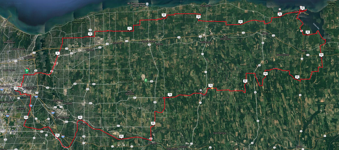 … even with only four stops. First at Kent Park outside Webster to make adjustments. Third (what happened to second?) in Sodus Point: a stop at the historic lighthouse … 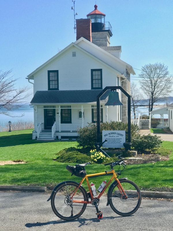 Sodus Lighthouse … and the out and back to the beachfront where I met an EMT taking a break. I asked her what all the construction work in town was about and she said she just got assigned to this area and didn't know. On my way back out, I met a couple homeowners on the street that was all torn up. They shared that the whole town was getting new utilities, bike lanes and break wall repairs and everything would be done by May. Last stop in town was a Coke and Nacho Cheese Doritos stop at the gas station. The forth short stop at the gas station in Walworth was a Coke and Reeses Peanut Butter Cup! That should get me the last 30 miles to home. But the highlight of the day, and the big time loss, was early in the ride at stop #2 when I finally side-tripped into Beechwood State Park. I've been by here a million times but never took the time to check it out. Today was a gorgeous sunny day so, why-not? 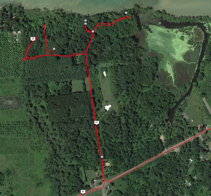 Exploring Beechwood State Park What I discovered is a pine forest that is owned by New York State but managed by the town of Sodus. The property looks like it's been abandoned by the state but in fact is a stunningly beautiful property along the shoreline of Lake Ontario. I ran into a group of hikers from Wayne County's "Trailworks" who were out hiking, and they shared the details. It was once a Girl Scout Camp, long ago, but later handed over to New York State. There's an effort to revitalize the park, and I'm inspired to help by gathering a group of like-minded cyclists for a camping outing sometime this summer. Who's in? See the photos below and get inspired! 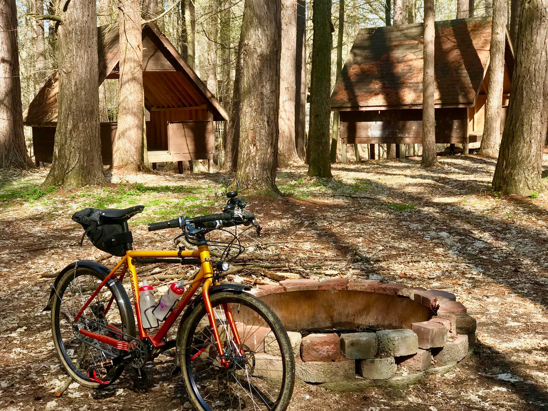 Sheltered Camping! Complete with Fire Ring! 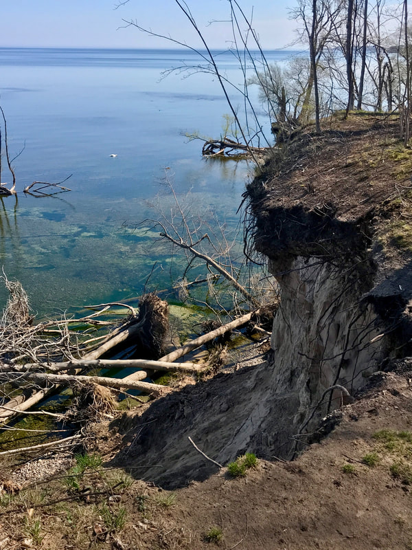 Dramatic Shoreline 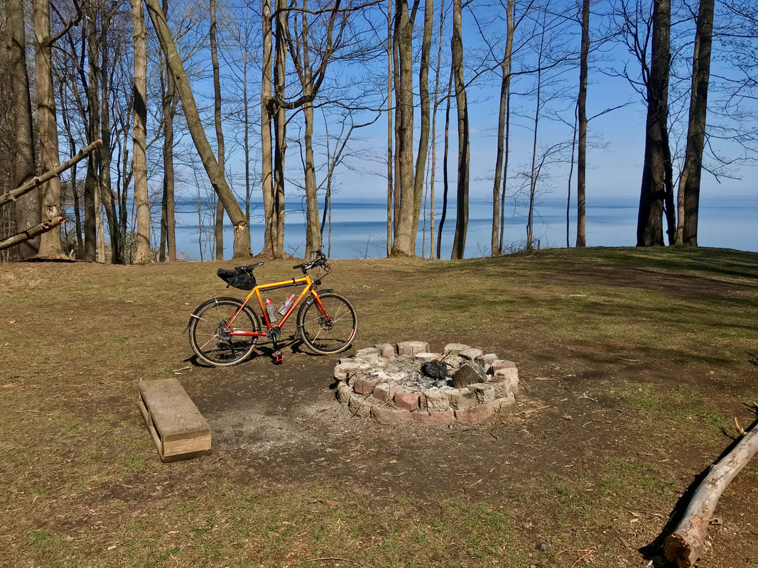 Perfect Tent Campsite! See the track file and zoom in to check out the Beechwood Park: https://ridewithgps.com/trips/65508884 Rubber Side Down! Finished yesterday's Big Bike Adventure a bit tired, but figured a decent night sleep would end up with a full recovery, and the weather report was looking fantastic, so … It's Time for a Century! Temps were to hit high 70's and wind were expected to be from the southeast all day, and getting stronger as the afternoon wore on, so I had a plan to use it efficiently by heading southeast first, and using the tailwinds to get back home. I could head to to Middlesex, just east of Canandaigua Lake, and grab a slice of pizza for lunch, then make a loop though Potter before heading home. Yet another great idea that didn't exactly work as planned. I used the Auburn Trail to get out of town in the direction of Canandaigua, since it's a great way to avoid morning traffic, PLUS … being in the woods for the most part shielded me from the headwinds for the time being. Once in C'daigua, I made my "regular" stop at the Dalai Java for a red-eye and a chocolate chip muffin —>> ROCKET FUEL. 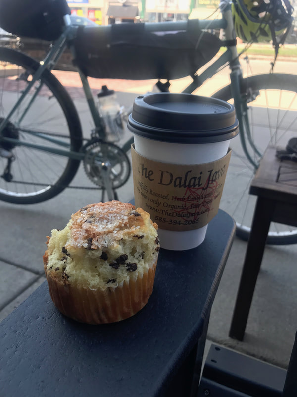 Little did I know how important that fuel might be. An AHA moment! Karen and I had ridden the section of the Ontario Pathways Trail from Route 96 to Stanley last year, but we had not yet done the section from Canandaigua to Stanley, and the start point was practically right around the corner. It would take me in the general direction to the southeast, and I could swing though Gorham on the way to Middlesex. Plus, it's more trail riding with tree cover for blocking headwinds. Sounds like an easy Century kinda day … Let's go! 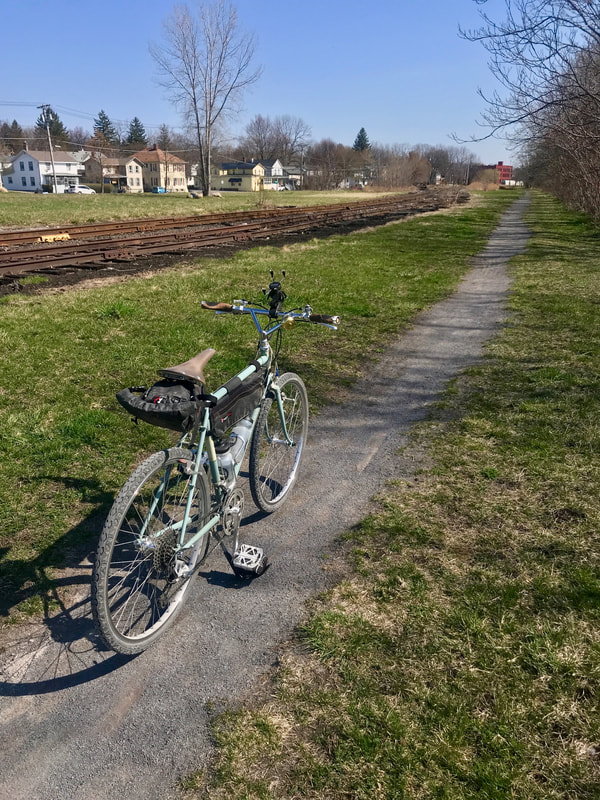 Well, you know how it goes when ya gotta plan, right? The Ontario Pathways route is really, really pretty, partly because it's a mostly natural surface trail. No wide stone dust like the Erie Canalway, but rather a mostly dirt and grassy and single track route since it's doesn't seem to get the traffic it deserves. But, that results in a problem in the spring in that the surface is soft, sometimes wet, and pretty slow rolling with narrower tires like I use on my Rivendell. I tended get mired in soft stuff and mud in a few places and it was tiring, no doubt. (Particularly since I determined I had NOT had enough sleep since yesterday after all!) But the trail is pretty and quiet and there's a fun section where words of wisdom from Pooh and friends are posted to a string of trees. Fun to read, but kills time if you're in a hurry. Which Pooh doesn't encourage anyway. 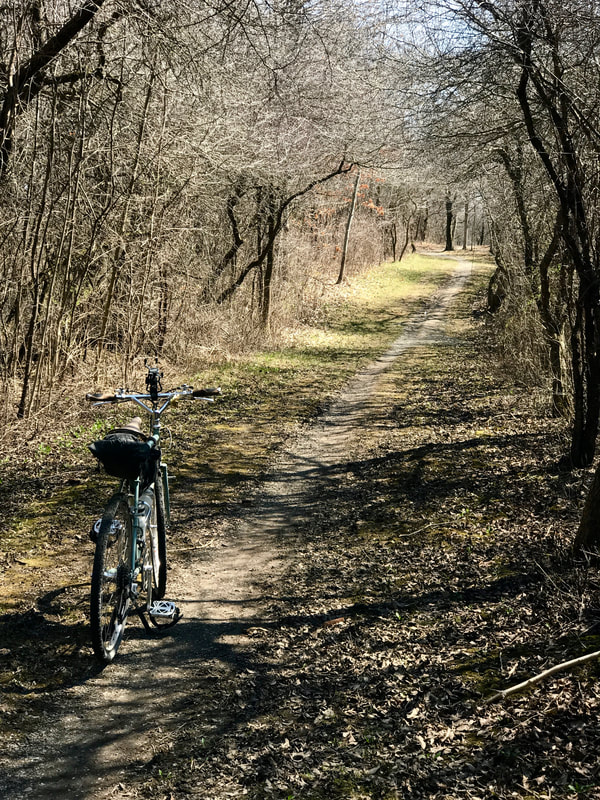 So, I'm chugging along a for a mile or two, I keep hearing a very faint "tink-tink-tink", trying to figure out the source. It get's to me … I stop … I spin the wheels … and find a little stick stuck to my tire. Stuck? Oh! It's got a thorn and it's stuck in the tire. No matter … it's in the thick part of the tread. I pull it out. HISSSSSSSS …. That's a first for these tires. Shouldn't be a surprise since they ARE getting worn after so many miles last year. I commence to doing the flat repair, pump up the tire and strangely struggle for way too long to get it back in the frame. I find that with the tire inflated, It doesn't get past the kickstand plate and into the dropouts, so I deflate, mount it, and pump it up again. Finally, back on the trail. I reach a cool bridge over Flint Creek. Clearly a pedestrian bridge as it's so narrow; I have to ride a VERY straight course across to avoid smacking the h-bars on the railings. Pretty cool. 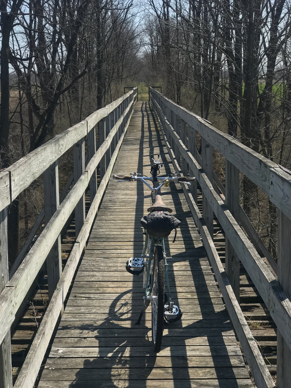 I get to Old Mill Road and as I cross, it seems I have a bit of bounce going on and off the pavement. Stop to check. Tire going soft! Pull it out and verify patch is holding fine, but now I have a valve stem failure! Too many of these lately. Hmmmm …. Pull out the spare tube, get it in, and rethink plan. I'm almost to the Stanley crossing … THAT goal achieved. But with no backup in case of another serious failure, going to Middlesex is out. So, I decide to head home, and THAT was a fun decision. Now I've got tailwinds like crazy and it's mostly downhill to Canandaigua. It took me 2 and 1/2 HOURS to get to Stanley from C'daigua, but under 45 minutes to get back … what a difference! I grabbed a coke at the c-store and hit the road as it's getting later. I'm still tired, and I've got miles to home. I head northeast to reconnect to the Auburn Trail but hop off before getting to Victor to go see the new roundabout at the east end of town. Up the hill to Victor Road toward Lollipop Farm where I snag the Trolley Trail into Fairport and use the Erie Canal Trail (no cars during rush hour!) to get back into the city. I had given up the idea of getting a century, but once in the city, I figured I could be easily rescued if I had another failure, plus … Karen has been out riding, and might not be home yet, so I went to GV Park, up the River Trail and wandered through the city streets on my way home. I guess I'll call this my "Five Trail Century". And I JUST squeaked it out as I pulled into the driveway. 100 miles, in 10 hours … just like always. 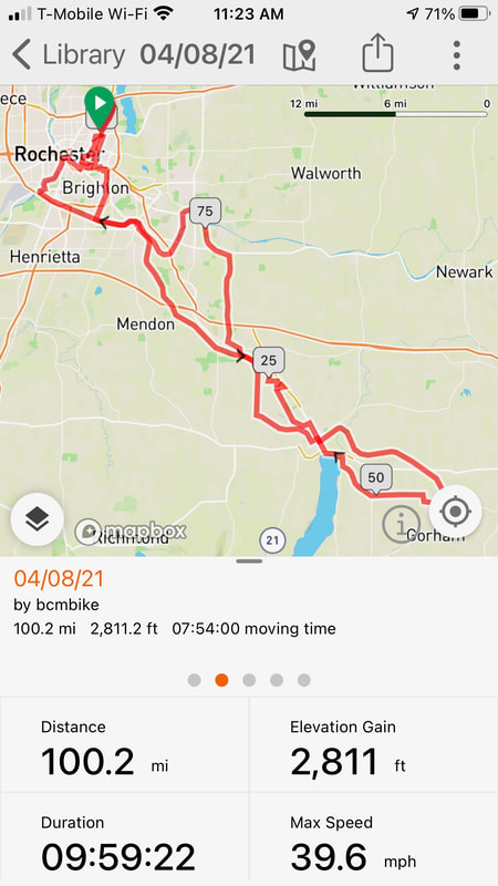 One Coffee, One Coke, and One muffin for the day. Karen had to steady me in the driveway as I got off the bike. Maybe next time I'll get TWO muffins ... one there, one to go! Century #1 for 2021. Maybe my last! (Just kidding!) When you get a couple back-to-back warm dry days in early Spring, what do you do with them? Ride … a LOT! Ride what? Always a good question when you have options, so it's helpful to have a plan. Always "planning" for something new, I've been toying with yet another biking adventure, and Wednesday's (4/7/2021) jaunt was in prep for that. Turn's out, Wednesday's "prep" was an adventure in itself. A friend had tipped me off to yet another cool map resource called "GravelMap.com" that displays known off-pavement roads as reported by users. A casual look at the map turned into a huge time-suck when I realized how many more such roads exist in our region. But more than just dirt/gravel roads, I discovered that users can input "routes" as well, and I hit the jackpot! One user, who appears to be a rally-car driver, mapped out a 150 mile route in the hills south of Naples, which in MY mind translates to a 3-day bikepacking tour. Oh yeah! Or, so I thought. With the idea in mind, but knowing the transitory nature of old dirt roads, I elected to ground-truth the route to determine if it REALLY was a viable route for mountain biking, and if a couple potential campsites would work. I split the route into three sections, with two overnights in state forest properties, hopped on "The Beast" and took off early morning.  The Beast An hour later, I refueled in Wayland before heading over to the Atlanta firestation to start recording the route. Paved back roads till Cohocton turned ominously to wet and greasy and crazy steep dirt roads into the hills, causing me to question this whole idea of trying this on the big bike. After a number of tense moments, I eventually relaxed, realizing I haven't lost my skill set and restored my faith in the bike's abilities. For a 500 pound bike, it really is quite nimble in the rough stuff. So things continued smoothly till I got to an unexpected detour. The guy who initially plotted this route appears to not have actually driven it. On the top of a hill, a narrow rocky trail led me to an intersection where the route pointed straight. I went about 1000 yards and came to gate across the road. The road was narrow enough, and with a steep drop-off on one side, I dared not try to do K-turns under power, so I shut down, got off, and man-handled a series of tiny K's to get the bike turned around without dropping it off a cliff into the woods. 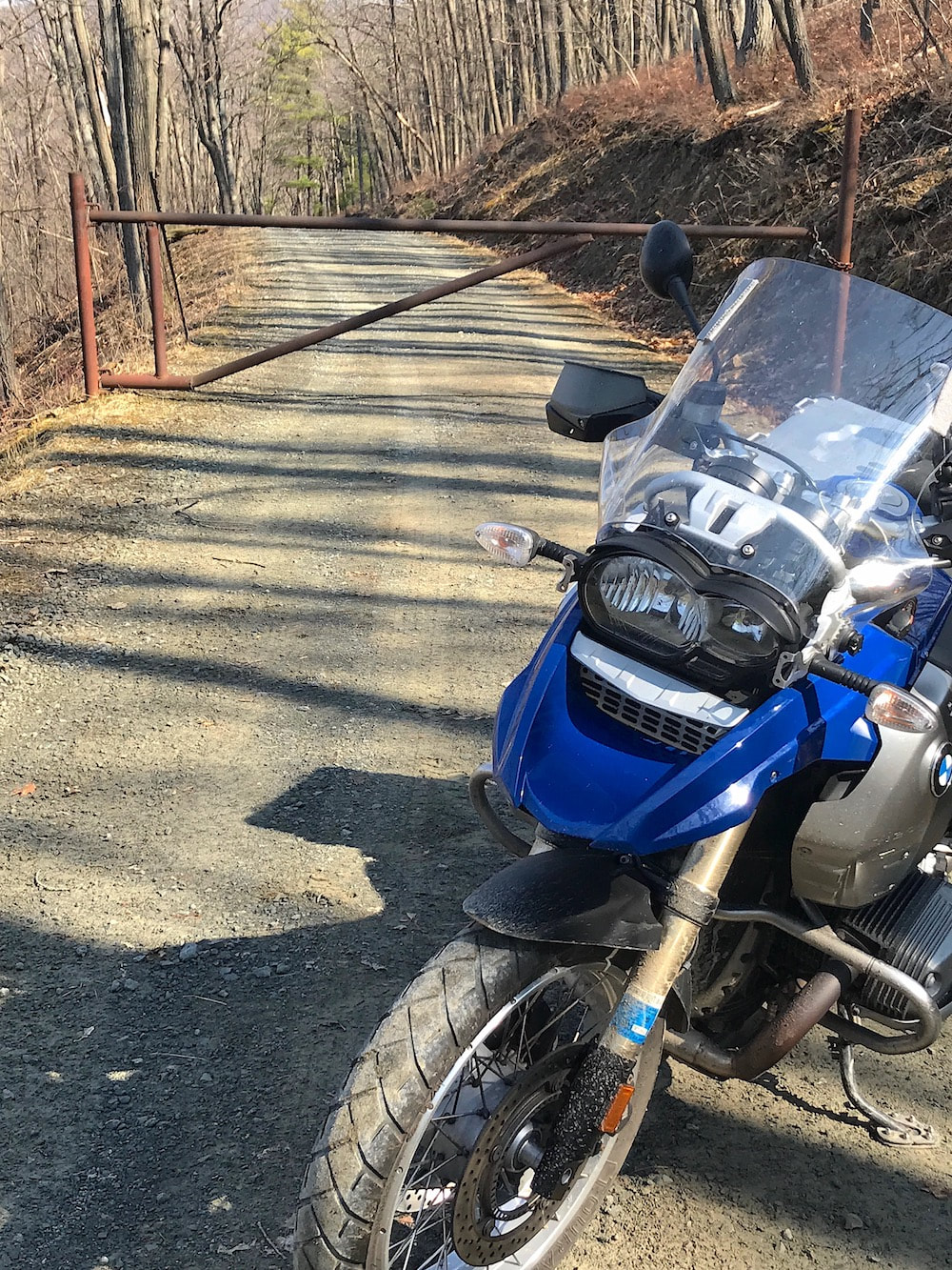 It LOOKED like a Great Idea! Suddenly, that nimble 500 pound bike didn't feel so nimble. Back to the intersection, I tried both directions out to find both closed due to a huge natural gas pipeline and storage facility had commandeered the entire hill. The only way out was back down the dirt trail to the highway, where I figured out the shortest path back to the planned track. 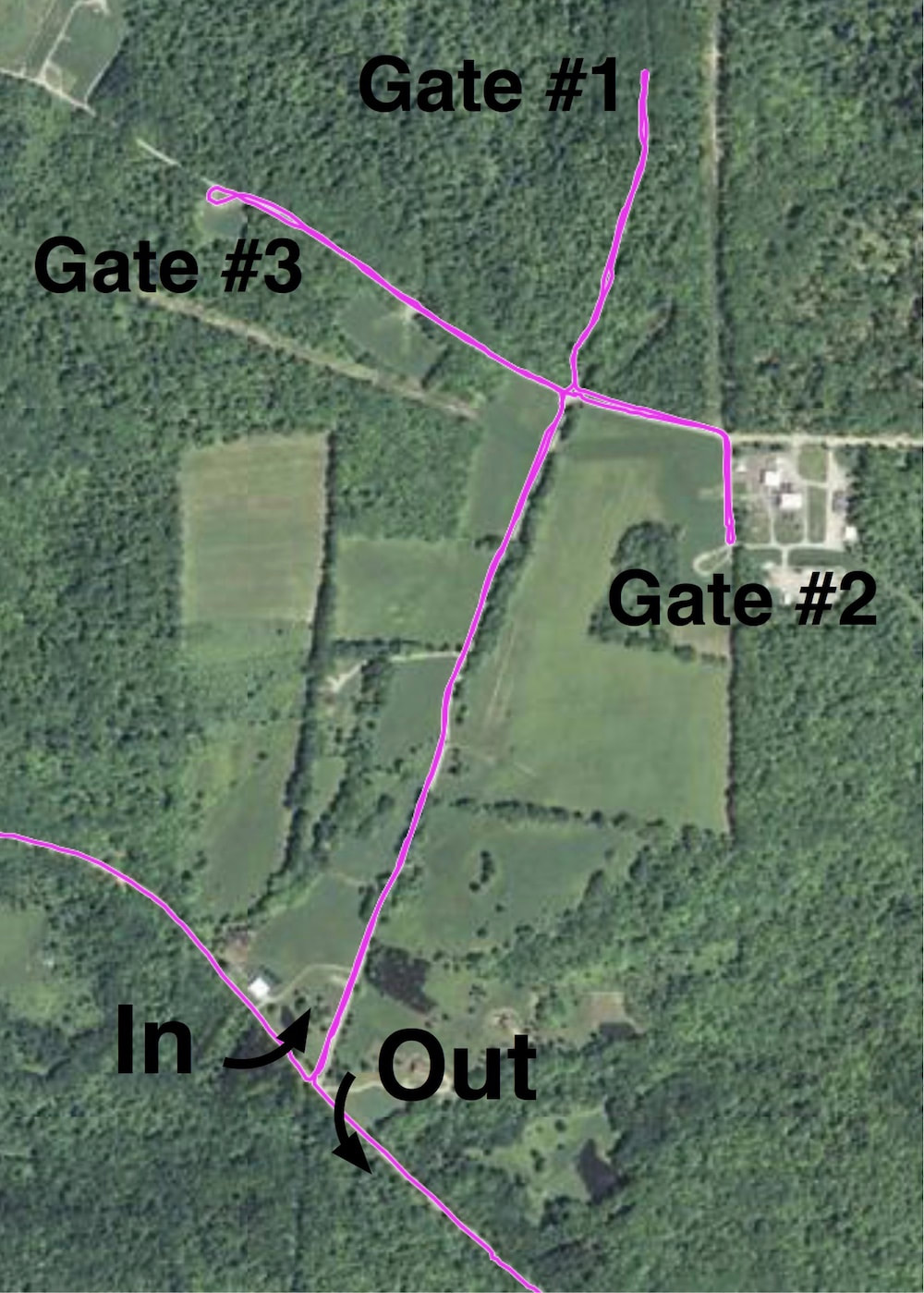 Back on route, the rest of the day mellowed out significantly … or maybe it was me. Many of the roads after this point were ones I'd already ridden on mountain bikes, or during a dual-sport event we've ridden called the "Thrills in the Hills" with the Wayne County Motorcycle Club, which they tag as "100 Miles of Bad Roads". Fun time. 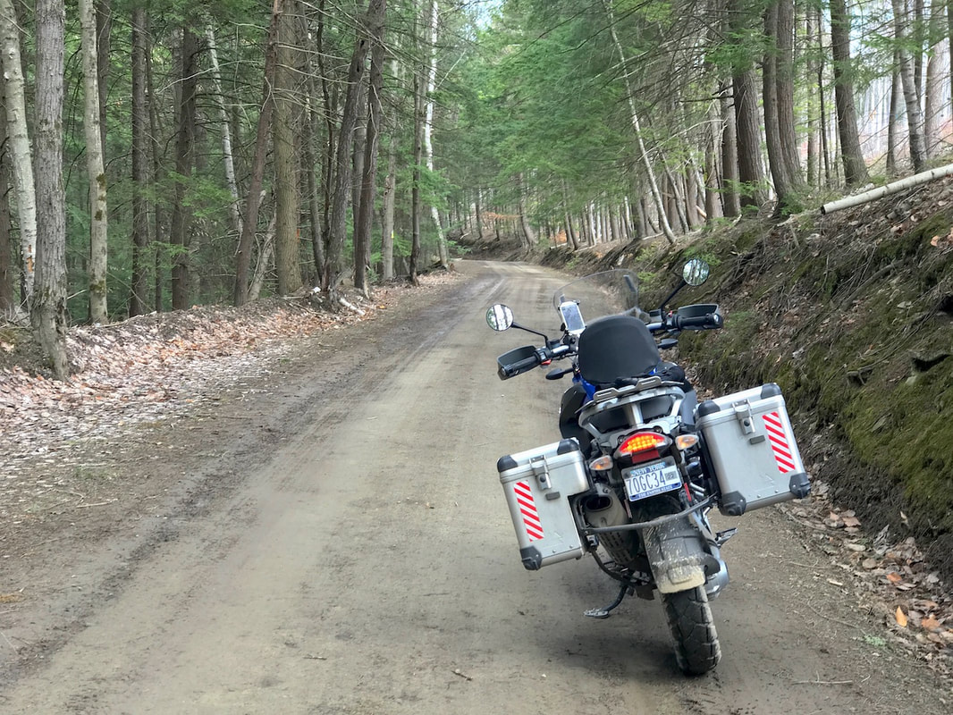 Looks Mellow Enough I finished the 150 mile route realizing a few things: 1. It's a wild good time on a motorcycle. 2. It's far too tough as a three day ride on a bicycle for this old man. 3. I'm dead set and determined to do it anyway. 4. So, I'll have to find a way to break it up into 4 or 5 days! Stay Tuned! 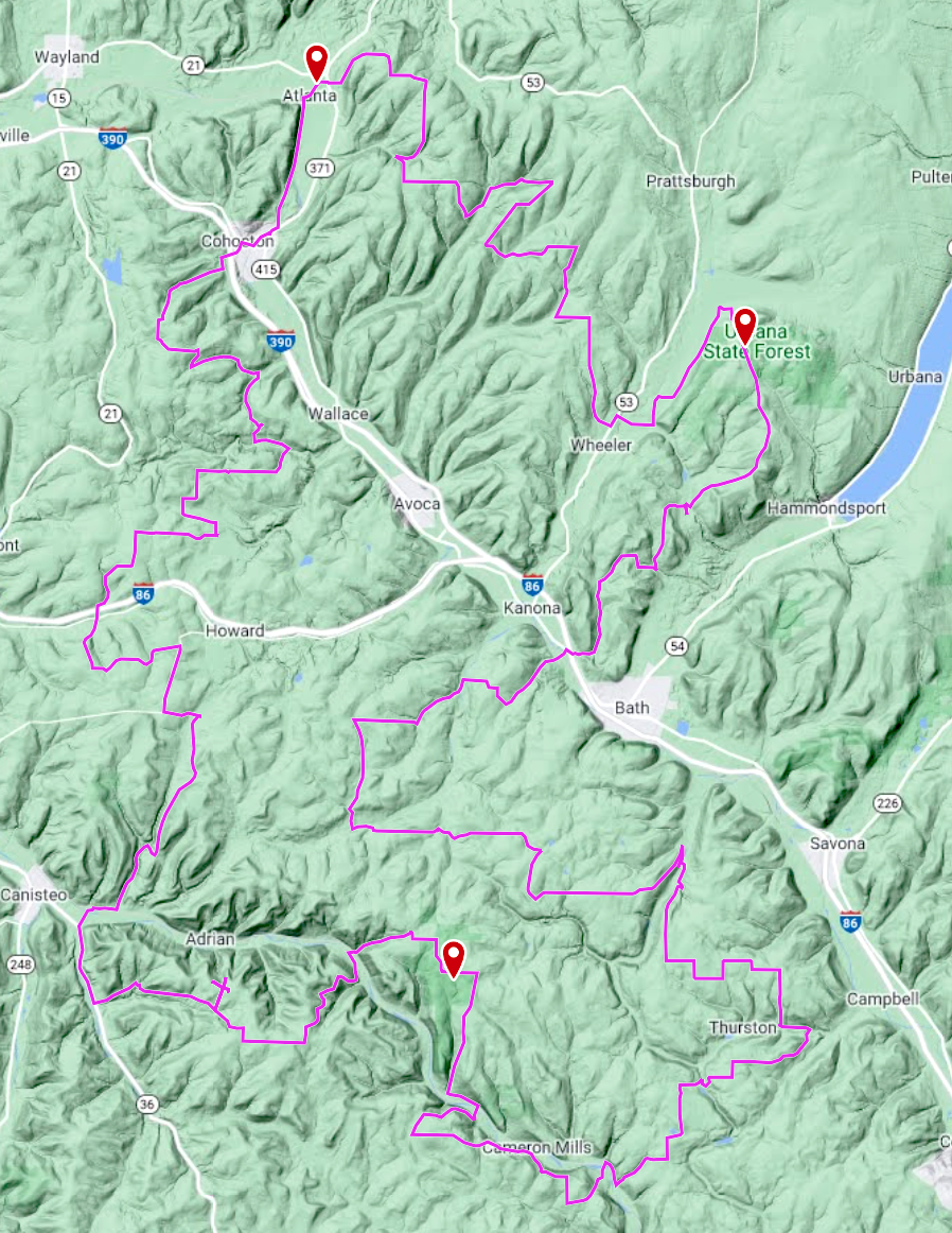 150 Miles of Sweat and Giggles
March is slowly "coming around" with intermittent breaks from the cold and wind, and I'm not one to miss a chance at a longer day ride when conditions permit. I managed a good one a week ago by riding 70 miles, to and from a ride start with friends on a gorgeous day that nearly hit 70 degrees. Yesterday wasn't quite as nice, but good enough for a 50 miler down the Genesee Valley Greenway to Avon, and back home via pavement. "Pavement" on the Pangea? Read on! I wanted to see the section NORTH of Scottsville once more before the new trail construction begins sometime this summer. 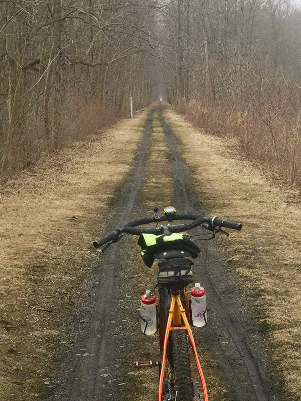 Looking South from Ballantyne Road Yup … plans are that the section from Canawaugus Park north to Ballantyne Road will get a face-lift in summer 2021. It will replicate the trail conditions that was created last summer from Canawaugus Park SOUTH to Route 5 (Avon). Wider, smoothed out, rolled with stone dust, and with some amenities added. So, the way I've always enjoyed the trail as a basic natural surface route out of town will be no more, and I decided to commit the image to memory … alongside the multitude of memories I've amassed since the trail's earliest days when I returned to Rochester in '91 and shortly thereafter got deeply involved with the Friends of the Genesee Valley Greenway as we hacked our way south. This will all be a grand improvement for most users and I expect that bringing the trail conditions up to match that of the Erie Canalway Trail, Lehigh Valley Trail, and the Auburn Trail will stimulate a significant rise in Rochesterians doing "The Loop" as well as inspiring more to explore southward toward Mount Morris, Portageville, and beyond. What's the "new" trail gonna look like? Kinda like this: 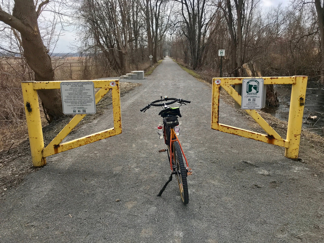 Looking South from Canawaugus Park In addition to upgrading the trail surface, there have been major environmental improvements, particularly in solving wet trail and wetlands issues on and near the trail. 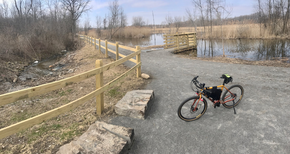 Wetlands Management Success! Alas, there's a glitch in the system, from my perspective as a cyclist. Yes, the Greenway is a multi-use trail. Wonderful! That means all kinds of normal trail users can enjoy it, thereby reaching many more people than any single-use type trail ever could. As a IMBA (international Mountain Bicycling Association) member from it's inception, I'm totally wedded to the concept which advocates for respect of all users and trail conditions. But I believe that respect isn't a one-way street … ALL users should respect ALL others and especially the trail conditions. So I was very disheartened to see this … 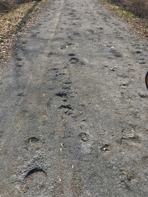 Horses tearing up the trail I had heard that people were getting out on the trail before it was completed and opened. And perhaps the trail had opened before the base and stone dust had truly hardened enough to withstand the impacts of horses. Or maybe there's a plan for periodic re-rolling to restore the trail surface. I don't know. But I'm disheartened to see that equestrians had been out there, done that damage, and not immediately recognized or cared what they were doing and continued riding along the entire length of the new trail. (Not to mention the piles of horse "by-products" right ON the trail.) I had planned on riding all the way to Route 5 and returning back to Rochester on the trail, but once I got to the south end, I diverted to Avon and rode the pavement home, even with soft knobby tires. If this will be the condition of the trail for keeps and not resolved, the only time I will reasonably tolerate the trail will be on my fatbike. That my friends, will certainly dissuade a lot of folks from biking the trail. I'm writing letters. You can too … Thanks! 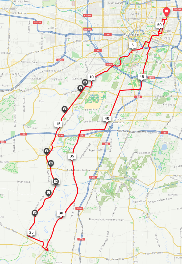 If you've followed this blog for a while, you'll know about my somewhat unconventional touring bike: my Co-Motion Pangea. Click here for the review and photo gallery on The Radavist. Yup! That's Mine! What makes it unconventional, yet imminently cool is the Pinion drive, an 18 speed internal gearbox. I selected this option on the custom build because I wanted ALL the best features of a ultra-endurance touring bike, namely high reliability, low maintenance, and the widest range gearing system (636%) of anything available on a diamond frame bike. I enjoy the speed of fast downhills and strong tailwinds (high-gears) but I NEED to be able to climb sickly steep hills with a full touring load (low gears). And, I like having "the perfect gear" everywhere in between. Yeah … weird statement from someone who has twice crossed the USA coast-to-coast on a single speed. That's a whole different story. So the Pinion drive promises everything I've needed. Except … The Pinion drive makes use of the Gates Carbon belt rather than a chain. Belt drives have a couple huge advantages over a chain drive system in that they require no lubrication and belts are many, many times more durable and longer lasting than chains. For one thing, they don't "stretch" with wear as chains do. And if belts can power motorcycles and 10,000 HP race cars, I'm sure they will hold up just fine under any load this old man can produce. And so far, that has proven true. With over 7000 miles on the belt to date under often "less than pristine" riding conditions, my belt is running just fine and the belt has far out-lasted any chain I've used and showing little sign of wear. Gates conservatively estimates a life-span of 20,000 kilometers but I've heard stories of them lasting 30,000 MILES! So, the "Except"? Chainring. ("Belt"ring, actually) The Gates Carbon belt uses front and rear cogs that match the belt. The preferred design for touring and mountain bikes is the "CDX" type which is an improvement over the urban-oriented "CDN". And now, the CDX line has been improved. When I got my bike, it was set up with the stock CDX ring, made of the 6061 series aluminum alloy. For those of us with machining and materials background, the 6061 series aluminum is a decent structural grade aluminum. We've all seen bike frames and other components advertised as made with this series. But, there's another "number" most of us have seen used in bike applications: "7075". This grade (and I'm not certain why) is often marketed as "aircraft grade". I haven't built any Boeings or Cessna's lately (although I've jumped out of MANY Cessna's, Beech 18's, and DeHavilland Twin Otter's), but I'll agree that 7075 is a far tougher and stronger (and more $$) quality grade than 6061. But that's what I started with. "Stock" stuff. And after 7000+ miles (much of it off-pavement), this is what my front ring looks like: 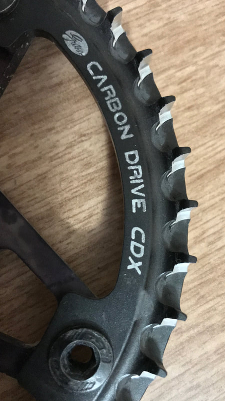 Note the scalloped condition of extreme wear on the teeth. Yup … that ring is toast. I've had regular, decent quality CHAINrings FAR outlast that! (OK … maybe except rings on my 1977 vintage, French made, Stronglight 99 crankset … THOSE were a yearly replacement) So, I had to find my options. I mean, who cares how long and economical the belt is if I hammer through rings like I do slices of pizza at c-stores on club rides? So looking into it, I find that Gates already has the solution. Admitting that 6061 series rings are likely OK for "regular" use but not so much for "abrasive" conditions (like, maybe … OFF-pavement?), Gates has released two alternatives. One is a CDX-SL ring made of 7075 aluminum. Cool! A friend who also has a Pinion drive sent me a photo of her CDX-SL ring with 4000+ miles, mostly gravel riding on it. 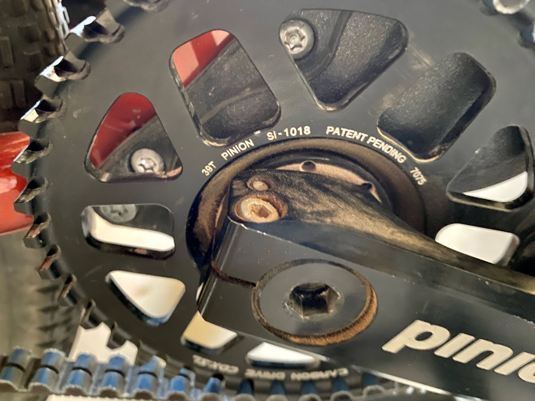 Far, far better looking than my stock 6061 ring, and major kudos to Co-Motion for building up her bike with the upgraded ring! (I'm unsure if they even existed when they built mine) But looking at her ring very closely, I can see the very slight beginnings of wear on her ring. Not bad, but it is beginning. When I was investigating solutions, I had a look at the entire drive train and noticed something interesting. The REAR ring at the wheel ... made of stainless steel and NOT aluminum ... shows exactly ZERO wear! 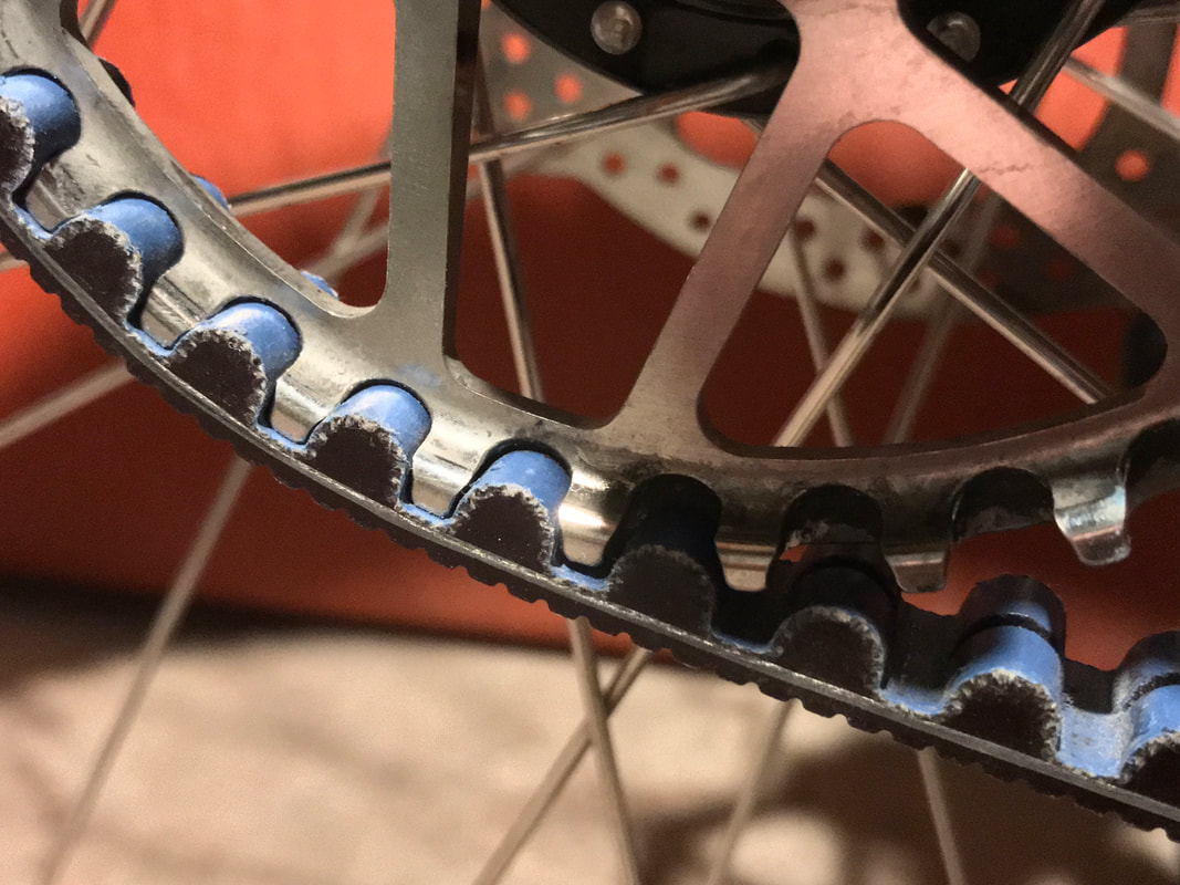 It's like it's brand new out of the box. AHA! Wouldn't it be cool if Gates made a FRONT sprocket made of stainless steel? They do! And I ordered it ... the CDX:EXP. That was an exercise in web searching since my LBS (my preferred way to support my bikes) had no access to Gates rings from it's regular sources, but I learned that Bikeman.com of Woolwich Maine is the USA distributor of Gates Carbon Drive components. (And coincidentally, the dealer for Carver titanium fat bikes as well … Hey, I can dream, right?) So, the new ring arrived yesterday, and I got it installed and test rode the bike in no time! Sweet! Silky smooth and dead quiet! 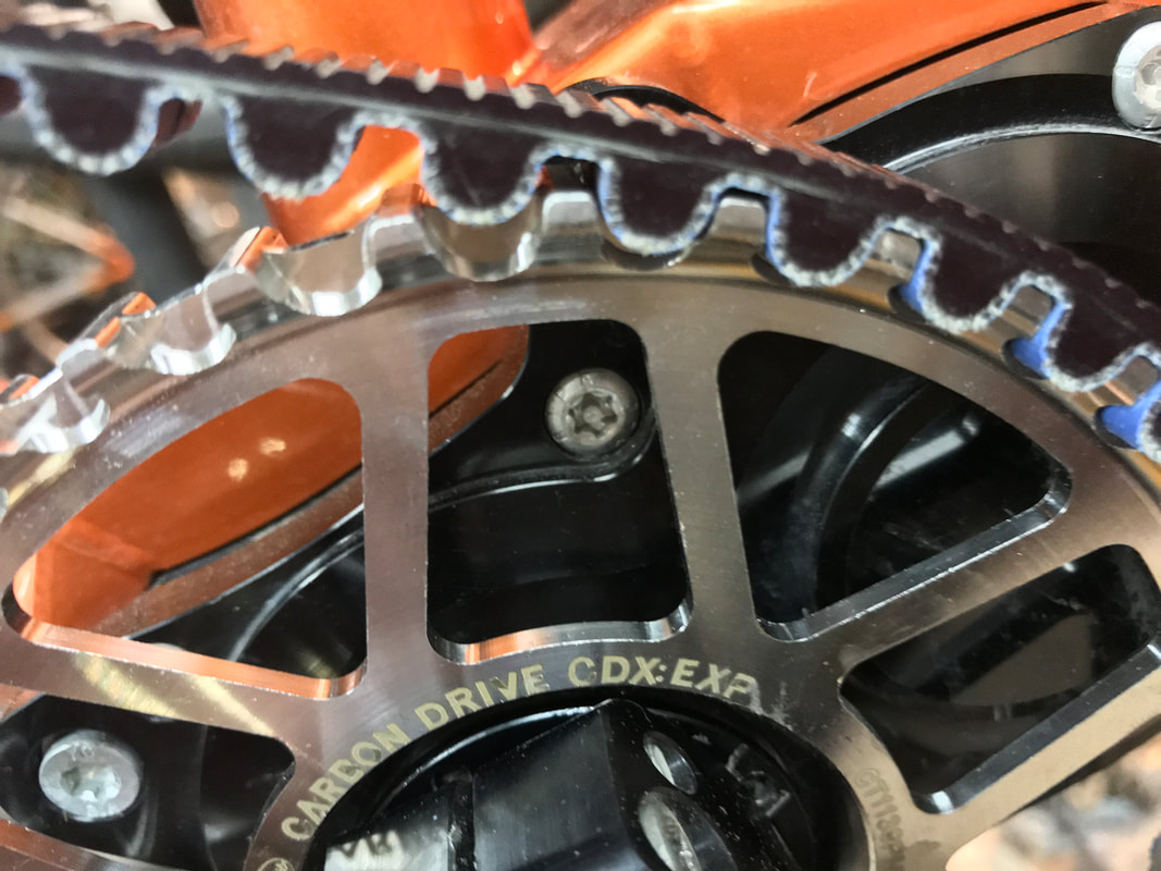 Being that it's a special part on a special bike, I needed a couple special tools, again. Yeah ... my bike tool collection continues to fill my machinist's roll-around, riser and top-box, but I've got room. To pull the ring, I needed Pinion's own lock ring tool … 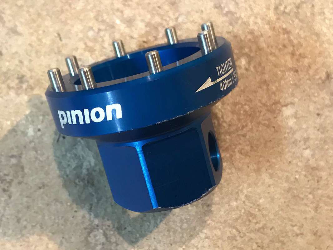 And similar to a chain whip, I needed the Gates strap wrench to hold the ring while unscrewing the lock ring. 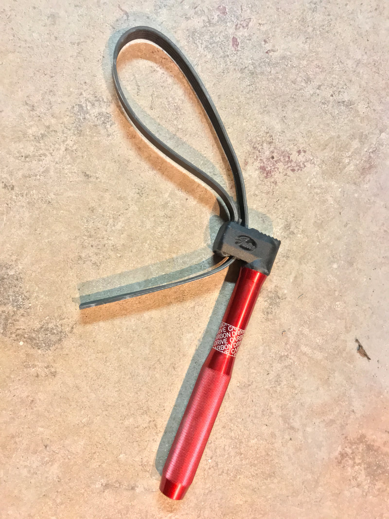 Now that I've got ALL the tools to maintain my maintenance-free bike, I wonder if I'll ever need any of them again. I guess I'll just have to ride the crap outta this bike and see what happens. Gee … what a problem!  So, OK … I had a plan. In my last post, I shared a picture of my mileage chart where I hit my 10,000 mile goal with a 58 mile ride with Karen, and pretty early … like in the first week of November. It didn’t take long for me to decide 10K was too easy and I needed to ramp it up since I had a month and a half left to 2020. So I poured on the coal and took a shot at 11,000, and in mid-December, I hit the mark. Certainly, there was no time left to hit 12K, so just for fun, let’s keep riding and hit a different mark: All Ones! So by New Year’s Eve, I needed only 6 miles to reach 11,111 miles. Karen had some local errands to do, so I plotted out route to hit her destinations without going OVER 6 miles. Watching the odometer, I got back to our street with 5.7 miles. Technically, rounding up would give me six, but noooo … it’s gotta stop at exactly 6.0 miles, clearly indicating there’s something wrong with this guy … but I did roll into the driveway at 6.0 miles after spinning up and down the street in front of the house. Two great loaded Tours, 25 Century Rides, Some great mountain bike rides, A handful of RBC club rides and rides with friends, and 11,111 miles … almost certainly my biggest ever year. And I counted about 100 days this year that I didn’t even ride!!! Should I go for 15,000 in 2021? 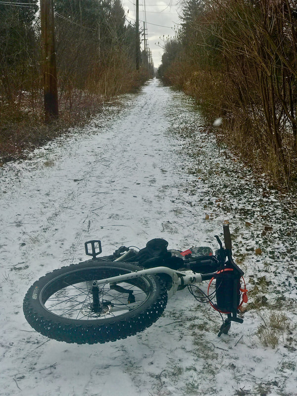 It was a beautiful sunny fall day with a chance to reach 70 degrees, and only the gentlest of winds. Karen volunteered to stoke the tandem to keep me company on my last ride to hit my goal of 10,000 miles for the year. No drama though. It’s not like I had to claw and crawl my way in the last days of the year to hit 10K. Finishing a month and a half early simply reminds me that I set my goal too low, if the idea was to really challenge myself. That’s not to say I’m done riding for the year. So, if I was ok to exceed my goal of 10 centuries, and hit 25 instead, I guess I could revise my mileage goal too. Maybe I’ll sleep on that. But today’s ride was wonderful no matter what the occasion. It was a simple route with little chance of a navigation error. Since the plan was to ride exactly 58 miles so that we’d finish right on 10,000 miles, then sticking to my (exactly 58 miles) pre-planned route was essential. Simple enough ... just ride eastbound out into Wayne County to a turn-around point that would route us through Pultneyville on the way home so that we could stop for lunch. 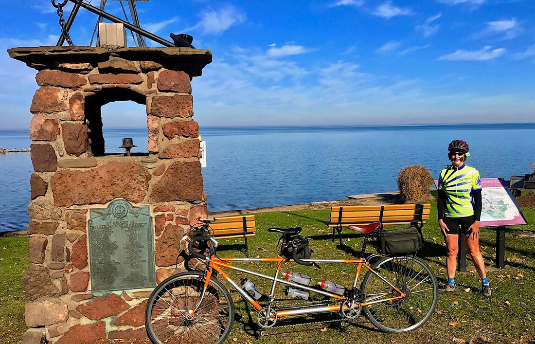 We had a nice lunch (split a chipotle chicken panini) sitting in the sunshine. The rest of the ride back was as quick and smooth as the outbound leg but we interrupted it once again by stopping at Abbots/Bill Gray’s for ice cream. Karen treated to celebrate the 10K. We pulled into the driveway at home with the ticker showing 58.20 miles.  So I reached BOTH of my cycling goals for 2020. Actually, two out of three when I count the Baja, but by that measure, I can say three out of four if my Erie/Mt. Greylock adventure is considered. I guess I’ll have to do better next year. 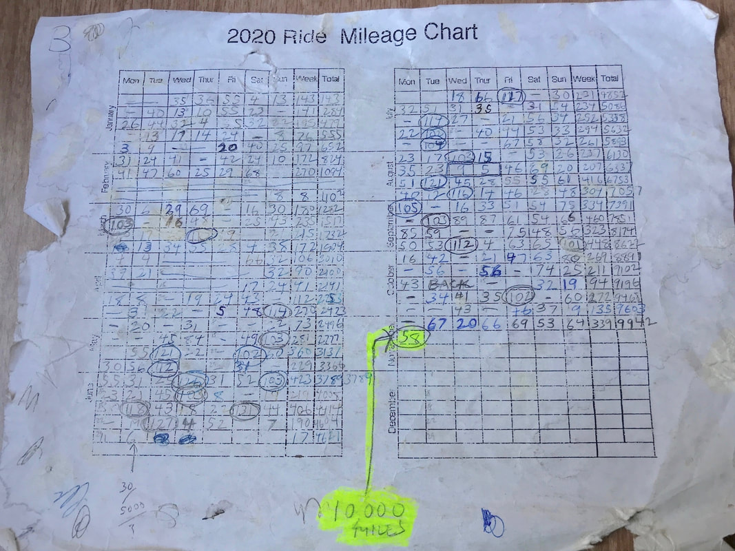 My chart looks to have suffered more miles than the bikes.
|

In the Finger Lakes

Slow Rides
Archives
October 2024
|
 RSS Feed